Severe weather risk still in effect for today, tonight
Published 11:29 am Wednesday, March 17, 2021
|
Getting your Trinity Audio player ready...
|
Weather forecasters are still calling for a significant severe weather risk for the area today and tonight, according to the National Weather Service.
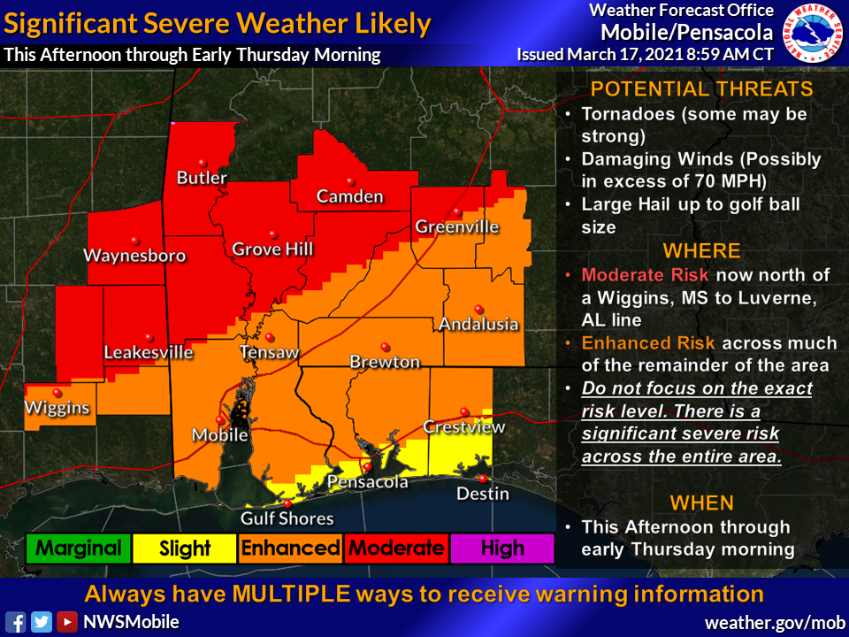
“Our confidence remains relatively high for a significant severe weather event this afternoon and tonight before the threat ends from west to east with a cold frontal passage,” NWS officials said. “All three modes of severe weather are possible – tornadoes (some strong, EF2 or higher), large hail and damaging wind gusts to 70 mph-plus. We have seen nothing in the data to sway original thoughts and the webinar slides that were sent yesterday, and reflect our collective current thinking on the What, When and Where aspects of this upcoming event. Now is the time to bring any final preparations to a close.”
Escambia County, Ala. and much of Escambia County, Fla. is under the enhanced risk category.
This afternoon through the evening, residents can expect isolated, discrete to semi-discrete supercell thunderstorm development after 1 p.m.
The thunderstorms will move from southwest to northeast across the CWA through about 9 p.m.
The environment is favorable for the production of strong tornadoes, damaging winds to 70+mph, and large hail upwards of golf ball size. The biggest question that currently exists is with respect to coverage during the afternoon and evening.
According to the NWS’s forecast from mid evening and tonight, an even more likely threat for severe weather will evolve during the late evening and overnight hours tomorrow night.
A line/broken line of intense thunderstorms will likely be ongoing along and ahead of the front, with embedded supercell structures.
The best timing for this feature will likely be between 9 p.m. to 1 a.m. across southeastern Mississippi, 11 p.m. to 3 a.m. over southwestern Alabama including areas west of I-65, and 1 a.m. to 6 a.m. for the Florida Panhandle and southwest/south-central Alabama east of I-65.
There remains uncertainty in regards to if the line remains broken or solid, which will have an impact on severe hazards\impacts, NWS officials said.