FEMA updates Atmore flood zones
Published 1:20 pm Monday, February 27, 2012

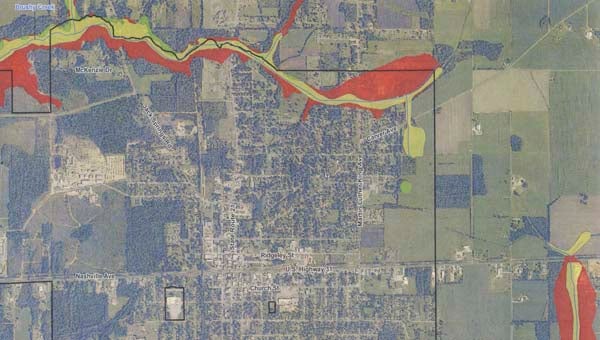
A portion of the newly released flood hazard zone map shows the largest impacted area inside Atmore's city limits, running through the north end of town along Brushy Creek.
The Federal Emergency Management Agency (FEMA), in coordination with the State of Alabama, recently released updated digital flood hazard maps for the Atmore area and changes to the map may have an impact on resident’s wallets.
Atmore city code enforcement officer Greg Vaughn said the new hazard maps were handed down to the city but will not go into effect until June 5 of this year, leaving local residents around three months to check the status of their property and find out whether or not they will be required to carry flood insurance.
Vaughn said residents and businesses will have up-to-date, internet-accessible information about their risk of flooding on a property-by-property basis. The revised maps will also serve as a guide for community planners, engineers and builders needing to make a determination about where and how new structures and developments should be built.
Flood Insurance Rate Maps (FIRMs) indicate whether properties are in an area of high, moderate or low flood risk and will determine if residents’ properties will require flood insurance. According to preliminary maps the majority of change in the Atmore Area is in the northern region of the city limits along Brushy Creek. Areas outside the city limits seeing dramatic change include the Brushy Creek area west of Atmore and the Pine Barren Creek and Beaverdam Creek areas located east of the city limits.
Preliminary maps may be viewed online at the Office of Water Resources’ website, http://www.adeca.alabama.gov/C16/Floodplain/default.aspx. The maps are also available for viewing at Atmore City Hall.
For residents who would like to learn more about possible insurance options information is available at www.floodsmart.gov.
The flood map modernization project has been a joint effort amongst Escambia County, the Alabama Department of Economic and Community Affairs Office of Water Resources and FEMA in cooperation with association and private sector partners.


