Heavy rain, storms to affect area today, tomorrow
Published 10:56 am Wednesday, February 5, 2020
|
Getting your Trinity Audio player ready...
|
UPDATE: As of 12:15 p.m., EMA Director David Adams said there are some heavy cells heading into the west end of the county now, and he’s already getting lightning alerts within 15 miles of Atmore.
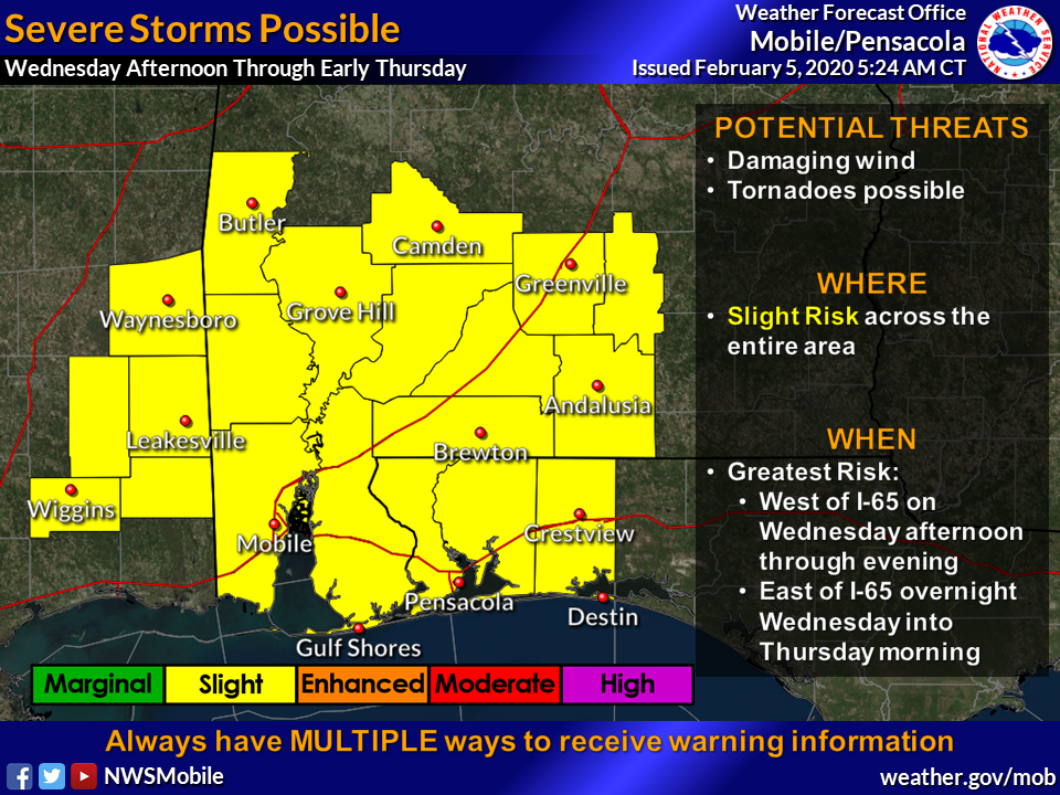
Heavy rain and severe storms will affect the area today through tomorrow, according to the Escambia County (Ala.) Emergency Management Agency.
Director David Adams said in a release today that the National Weather Service shows good confidence in the potential of heavy rain and severe storms.
“Several rounds of rain and thunderstorms will be expected beginning midday today and persisting into Thursday as a strong cold front slowly moves through the area,” Adams said. “A flash flood watch has been issued for most of our area.”
Adams added that the area is also under a slight risk for severe weather.
Specifics on the heavy rainfall and severe weather potentials are the following:
Heavy Rain potential:
- Highest Threat Level: Elevated
- When: Rain will begin Wednesday and persist through Thursday. The best potential for heavy rain will be late Wednesday afternoon into early Thursday morning.
- What: Heavy rainfall of widespread 2 to 4 inches with 3 to 5 inches within the Flash Flood Watch. Locally heavier amounts of 6 inches or more will be possible, especially along the I-65 corridor. Flash flooding along with river flooding could be possible.
- Where: The entire area with the main axis likely along and southeast of the Interstate 65 corridor.
- Confidence: High
Severe potential:
- Highest Threat Level: Slight
- When: Rain will begin midday Today and persist through Thursday. The best potential for severe storms will be late Wednesday afternoon into early Thursday morning.
- What: Severe thunderstorms with damaging winds and possible tornadoes.
- Where: Strong to severe storms will be possible across our whole area. The best risk will likely be along the coast and east of I-65.
- Confidence: Moderate for Wednesday afternoon into Thursday morning.
Adams said possible flooding may occur during the storms.
“The forecast from the River Forecast Center has the crest for Murder Creek at Brewton at just over 23 feet on Friday morning,” he said. “This will be very close if not over Highway 41. Please watch this closely and plan accordingly. If water covers the roadway, turn around and do not cross it. You cannot determine the depth of the water or if the roadway or bridge may be damaged or washed out.”