EMA: Several hazards to impact area through Saturday
Published 11:36 am Wednesday, January 24, 2024
|
Getting your Trinity Audio player ready...
|
Several hazards will impact the forecast area through Saturday, according to Escambia County (Ala.) EMA officials.
Director David Adams said in a release that the hazards will affect the area through Saturday, including potential severe weather, heavy rainfall and flash flooding, dense fog, and high surf/rip currents.
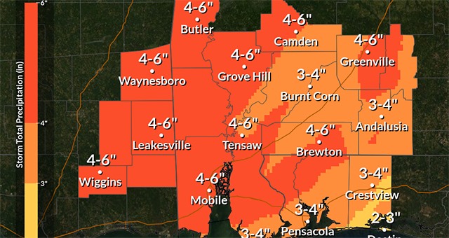
Adams said several rounds of heavy rain and thunderstorms are expected each day until a cold front clears the area late Saturday into Sunday.
More details on each of the hazards are below.
Impact 1 – Heavy Rainfall and Flash Flooding
- WHAT: Several rounds of rainfall are expected between now and Saturday. Storm total rainfall amounts of 3-6 inches are expected, though locally higher amounts are possible. A stalling boundary across southeast MS into southwest AL today into Thursday will focus heavy rainfall and flash flooding potential. A flash flood watch goes into effect for these areas this afternoon through Thursday evening and may need to be extended later.
- WHEN: Today, mainly west of I-65 (greatest potential of 3+ inches). Thursday for the entire area. Friday and Saturday, mainly for our eastern areas.
- WHERE:West of I-65 has the best chance of flash flooding potential today, with potential overspreading the entire area Thursday through Saturday. Greatest chances of flash flooding will be across urban and low lying areas.
- CONFIDENCE: Best confidence is for today across the flash flood watch area, lower confidence beyond today.
Impact 2 – Isolated Severe Thunderstorms
- WHAT: There is a low probability of severe thunderstorms west of I-65 today and all of the forecast area Thursday. Another potential for organized severe storms exists Saturday. The threat today and Thursday is relatively low, with a storm or two potentially producing a tornado and/or damaging wind gust to 60mph.
- WHEN:The afternoon and evening hours today and Thursday, Saturday all day (timing to be refined moving forward)
- WHERE:The western half of the forecast area today, all of the forecast area on Thursday. South-central Alabama on Saturday
- CONFIDENCE: Confidence is low with regard to the severe threat.
Impact 3 – Marine and Coastal Dense Fog
- WHAT: Widespread fog is expected, with visibility reduced to 1 mile or less, creating hazards conditions in our waterways and along I-10 and the Causeway over Mobile Bay. Patchy dense fog may impact portions of the western Florida Coast beginning tonight into Thursday, though confidence is low.
- WHEN:Marine dense fog over our waterways and Mobile Bay will persist through at least Thursday morning, potentially remaining through early Saturday.
- WHERE:Mobile Bay, MS Sound, and AL Guff waters out to 20nm
- CONFIDENCE: Confidence is high regarding the widespread dense fog west of Pensacola. There is lesser confidence in fog impacting coastal waters east of Pensacola given warmer water temperatures.
Impact 4 – Coastal Impacts
- WHAT: Dangerous surf up to 4-7 ft and dangerous rip currents.
- WHEN: Through tonight for the high surf and through at least Saturday for the rip current threat.
- WHERE: All AL/NW FL Gulf facing beaches.
- CONFIDENCE: Confidence is high in coastal impacts.